@bcarter wrote:
I’m setting up a base on a new location (i.e., coordinates are unknown) using CORS data. I logged data for 2 hours at the location and I know what to do with that data. I have downloaded data from a CORS site (in US) from the User Friendly CORS site. Here’s a view of what I selected:
These are the files that I received:
I realize that I need the .sp3 file, but which others do I need?
Heres what the Readme file says about the extensions:
.18o - GNSS code and phase data
.18n - Broadcast GPS orbit information
.18g - Broadcast GLONASS orbit information
.log- current and historical data for CORS site (pretty sure I don’t need this one).The RTKLIB manual is not particularly helpful here.
As a reference, here are my settings: First, I reset to factory settings (I’m fully updated- v. 2.11.0) and only changed the following (not that all broadcasting was turned off).
RTK Settings Tab
- Positioning Mode= Single
- GPS AR mode= Fix-and-Hold
- GLONASS AR mode= On
- Elevation Mask= 15
- SNR Mask= 35
- Max acceleration vertical- 1m/s2
- Max acceleration horizontal- 1m/s2
- GNSS selected: GPS, GLONASS, GALILEO, SBAS (BEIDOU is grayed out)
Logging Tab.
- Raw Data- Rinex 3.03
- Position- XYZ
- Base correction- OFF
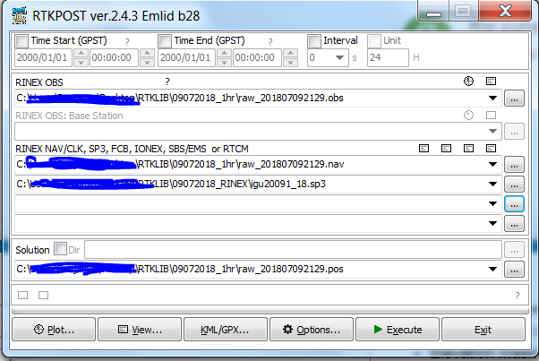
This is what RTKPOST looks like at the moment:
I think that should be everything, but let me know if more information would be helpful.


Posts: 1
Participants: 1